Pick your weather poison across Minnesota. Our potent inbound spring storm will produce a wide variety of weather in the next 36 hours.
We’ll see record warmth, potential lightning, thunder, wind and hail, and even a few tornadoes possible in parts of southern Minnesota Friday evening. Then heavy wind-driven snow and winds to 55 mph will cause blizzard conditions in western Minnesota by dawn Saturday.
Did I miss anything?

Blizzard warnings
Rain will rapidly change to heavy, wet wind-driven snow in western Minnesota between 3 a.m. and 6 a.m. Saturday morning. Throw in wind gusts to 55 mph in open country and you get an instant March blizzard.
Here are some more details:
URGENT – WINTER WEATHER MESSAGE National Weather Service Twin Cities/Chanhassen MN 211 PM CDT Fri Mar 14 2025
…WINTRY MIX LATE TONIGHT WILL TURN TO HEAVY SNOW EARLY SATURDAY MORNING WITH BLIZZARD CONDITIONS EXPECTED…
A powerful storm system will bring all types of spring weather to western Minnesota through Saturday. Showers and a chance of thunderstorms will arrive this evening. The rain will turn to a wintry mix late tonight, then to moderate or heavy snow early Saturday morning as much colder air arrives.
Snowfall rates of 1 to 2 inches per hour are possible at times. Northwest winds will increase significantly during the transition with gusts as high as 60 mph into Saturday afternoon. The snow combined with strong winds will lead to blizzard conditions. A Blizzard Warning has been issued for much of west central Minnesota with a Winter Storm Warning for Todd County.
Douglas-Stevens-Pope-Lac Qui Parle-Swift-Chippewa-Yellow Medicine- Including the cities of Morris, Benson, Montevideo, Granite Falls, Madison, Alexandria, and Glenwood 211 PM CDT Fri Mar 14 2025
…BLIZZARD WARNING IN EFFECT FROM 5 AM TO 4 PM CDT SATURDAY…
* WHAT…Blizzard conditions expected. Total snow accumulations between 3 and 6 inches, sleet accumulations between one tenth and two tenths of an inch, and ice accumulations around a light glaze. Winds gusting as high as 60 mph.
* WHERE…Chippewa, Douglas, Lac Qui Parle, Pope, Stevens, Swift, and Yellow Medicine Counties.
* WHEN…From 5 AM to 4 PM CDT Saturday. * IMPACTS…Whiteout conditions are expected and will make travel treacherous and potentially life-threatening. Widespread blowing snow could significantly reduce visibility. Strong winds could cause extensive damage to trees and power lines.
Winter storm warnings
Farther north, winter storm warnings have been issued for as much as a foot of heavy wet snow across much of northwest Minnesota:
Including the cities of Emmaville, Baudette, Ponemah, Red Lake, Menahga, Bemidji, Rosby, Park Rapids, Bagley, Nary, Clearbrook, Staples Airport, Redby, Wadena, Hubbard, and Lavinia
207 PM CDT Fri Mar 14 2025
…WINTER STORM WARNING IN EFFECT FROM 4 AM TO 7 PM CDT SATURDAY…
* WHAT…Heavy mixed precipitation expected. Total snow and sleet accumulations between 3 and 6 inches. Up to a foot of snow is possible. Ice accumulations up to one tenth of an inch. Winds gusting as high as 45 mph.
* WHERE…Portions of central, north central, and northwest Minnesota.
* WHEN…From 4 AM to 7 PM CDT Saturday.
* IMPACTS…Plan on slippery road conditions. Gusty winds could bring down tree branches.
Severe risk
A severe weather risk continue for much of southern and eastern Minnesota.

On the map below, the National Oceanic and Atmospheric Administration’s FV3 model still shows an arcing line of storms pushing north into southern Minnesota by around 6 p.m. Friday evening.
Storms may weaken a bit as they approach the Twin Cities and central Minnesota after 8 p.m. through late Friday evening.
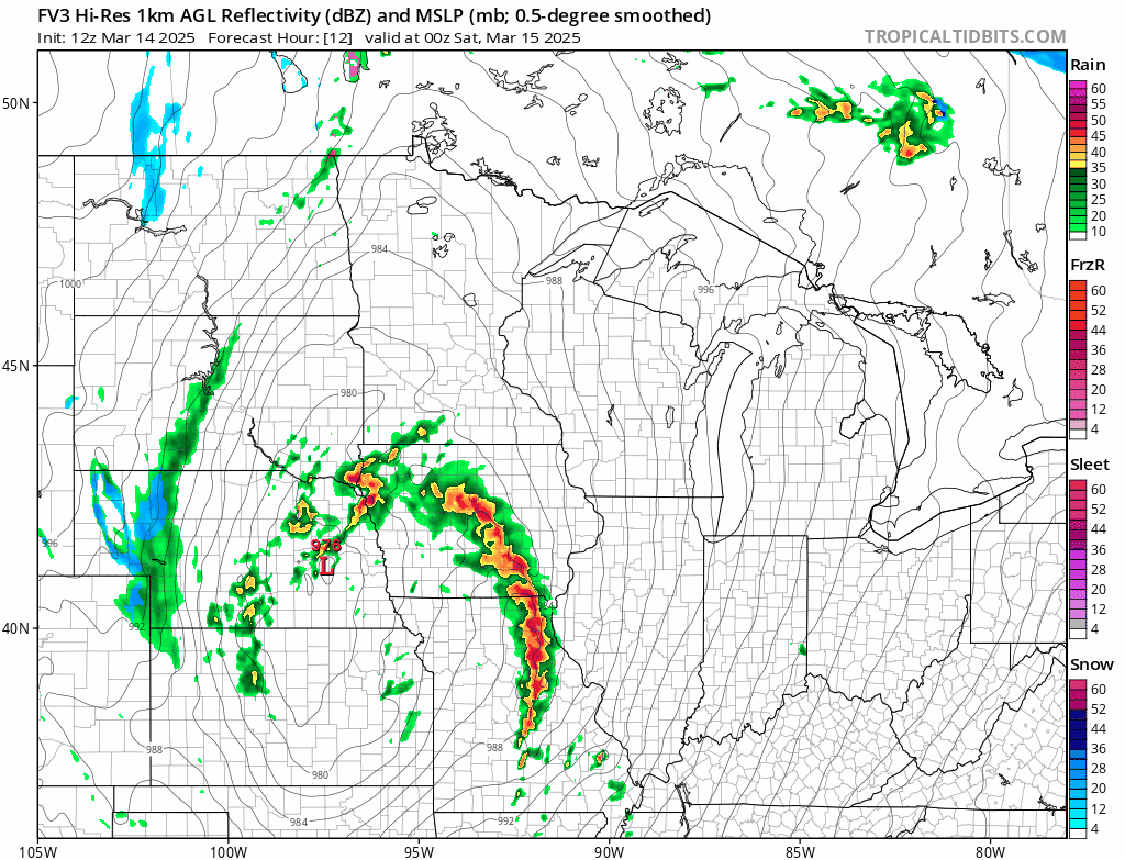
The highest risk for damaging winds and hail and a possible tornado lies across southern Minnesota especially the Interstate 90 corridor. Storms may weaken a bit as they move north into more stable air after dark, but it still could be feisty to potentially severe.
Temperatures will crash this weekend into the 20s and 30s.
Monday and Tuesday bring milder air back once again.

The forecast models still crank up another heavy snow event next Tuesday night and Wednesday. The latest storm track favors southeastern Minnesota.
Stay tuned.
Collected from Minnesota Public Radio News. View original source here.