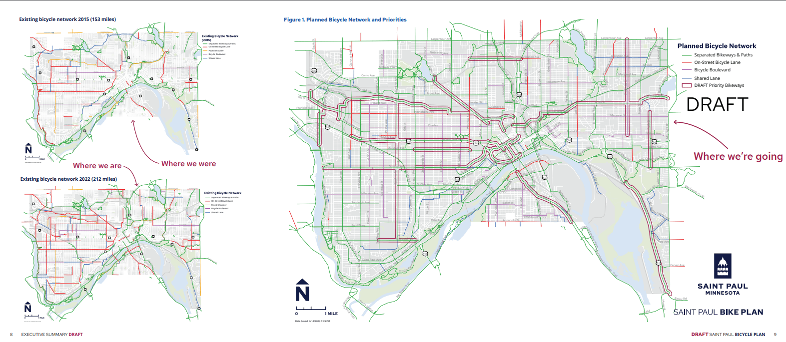
The future for bicycling just got a bit brighter. The St. Paul City Council unanimously approved a bicycle plan on Wednesday that lays the framework for installing protected off-street bike lanes. Council members Anika Bowie, Mitra Jalali, Saura Jost, Hwa Jeong Kim and Cheniqua Johnson voted in favor. Councilmembers Rebecca Noecker and Nelsie Yang were absent at the time of voting.
St. Paul residents can expect to have an easier time navigating the city with the addition of up to 163 miles of new bikeways in the coming years.
“I think this was a tremendous win for the community of St. Paul and the folks that live there,” said Michael Wojcik, the executive director of the Minnesota Bicycle Alliance. “They’re going to experience a more prosperous, livable, more environmentally friendly, sustainable city.”
City officials say this is part of their long-term goal to reach a total of 335 bike lane miles by the year 2040.
“I think the Twin Cities metro is the best bicycling metro in North America,” Wojcik said. “Time and time again, we see incredible new leaders stepping up and making decisions to really turn us into a world class city where everybody is safe getting around.”
This measure builds on the previous plan to overhaul the city’s bike infrastructure back in 2015. It made room for 200 miles of bike lanes and paths to be added within city limits; an ambitious plan to double St. Paul’s bike infrastructure at the time of adoption.
According to the city, it has added 59 miles of bikeways since the original plan was adopted. The major updates so far can be seen near the St. Paul Grand Round, Capital City Bikeway and the Highland Bridge development.

“What this is going to do is it’s going to close the gaps not only all over the community, but also also to surrounding communities as well,” Wojcik said. “So those who might be comfortable going if they had a safe route the entire way, they’re more likely to experience that in the future. And the specific kind of infrastructure is probably going to change from project to project. But in general, you’re going to feel very safe in that environment.“
On the social media platform X, Ward 4 Council member Mitra Jalali says the plan makes the city “safer and sustainable” and anticipates the use of funds from St. Paul voter-approved local sales tax.
Council member Jalali goes on to say the changes in the ward she represents includes updates to Hamline Avenue, Pelham Boulevard and Territorial Road.
Officials behind the effort say they will pursue additional external funding to construct bikeways separate from ongoing street reconstructions and work with railroad companies to build bikeways in or alongside rail corridors.
“One of the challenges is you can have a great trail, but you have little sections that don’t necessarily feel safe,” Wojcik said.
Wojcik, who strongly advocated for the plan, believes this sweeping update will make room for safer trails and ultimately encourage more residents to use bicycles more regularly.
“If you count the number of people who use bicycles as a primary mode of transportation, it’s really much lower than what it potentially could be,” he said. “You wouldn’t expect people to necessarily cross a river if there’s not a safe bridge there. Just as we don’t necessarily expect to see people bicycling as a daily way of getting around until the infrastructure really makes them feel safe. And that’s an important part that’s been missing in a lot of sites in St. Paul, and their leadership stepped up in a big way.”
The recently signed plan also places a greater emphasis on separated bike lanes to allow for safety and more room between cyclists and drivers.
“In [the past 60 years], annually we see about 1.3 million people dying from automobiles,” Wojcik said. “On the world stage, we’re seeing record number of cyclists being killed here in the United States. And what this was really about is equitable transportation and transportation that allows for better uses of cities as well.”
The city of St. Paul believes this move will also narrow roadways, which will lead to calmer traffic and shorten crosswalks. Critics are worried that this measure will cut down on street parking and prioritize spending on these lanes over creating road infrastructure. However, Wojcik believes those arguments do not take the bigger picture into account.
“This is a long ranging plan,” said Wojcik. “You know, core cities here in Minnesota and around the country continue to really do incredibly well and attracting young people and becoming a desirable place to live. And I think what you’re going to see out of this as a healthier, more prosperous St. Paul. The streets are still going to offer everyone regardless of how you’re getting around the opportunity to get there using that mode. But people who bike, walk, transit or roll are just going to be a lot safer. And the entire city becomes more accessible to them.”
Collected from Minnesota Public Radio News. View original source here.
 Minnesota Public Radio (MPR) is a public radio network for the state of Minnesota. With its three services, News & Information, YourClassical MPR and The Current, MPR operates a 46-station regional radio network in the upper Midwest.
Last updated from